Work Smarter with Maps in PTCAD
Import, Scale, and Draw Over Real-World Data
If you’re working on site layout, land development, infrastructure, or surveying — maps are a big part of your design process. With PTCAD, you can bring maps directly into your drawing environment and turn them into practical CAD geometry.
✅ Why Use Maps in CAD?
Maps help you:
-
Work with real-world coordinates and locations
-
Plan roads, buildings, or utilities based on actual terrain
-
Collaborate with surveyors or government data
-
Avoid errors and misalignment with satellite or GIS overlays
🧩 What Kind of Map Data Can PTCAD Handle?
PTCAD supports various ways to work with map or geographic data, such as:
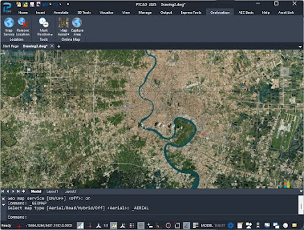
1. use command GEO
You can insert aerial maps, satellite images, or scanned survey plans using:
Use command GEO
click Load current location
User can turn on/off map
2. command MAPIMPORT
Using command MAPIMPORT for importing map data in several format suchas SpatialSDF, SpatialSQL, ESRI shp and database servers
🛠️ Example Workflow: Plot Layout from Map
-
Import map image or vector
-
Attach JPG/PNG , SHP
-
-
Scale map
-
Use known length (e.g. 100m road)
-
Use
ALIGNorSCALEcommands
-
-
Trace boundaries
-
Use
POLYLINE,LINE,HATCH
-
-
Add site layout
-
Add proposed buildings, roads, drainage, etc.
-
ADD data layer to map infomation to line or polyline in map
- Create new layer
- Add attribute and link with line in map
🧑🔧 Who Is This For?
-
Civil engineers designing roads, water supply or housing
-
Architects city planning in real land plots
-
Contractors checking terrain
-
Surveyors converting paper maps to CAD
-
Government-related projects (air quality, zoning)


No comments:
Post a Comment